|
|
 |
Petition signed by 200 from French Broad and Holston Country, dated 1813, from citizens south of French Broad and Holston bet the Rivers Tennessee and Big Pigeon, asking the State for relief of the debt owed for their land, due to the scarcity of specie (money) due to the aggression of the enemy . . . "the state removing the land would turn out many hundreds of families out of the houses and homes they have had for many years -- many grants were issued by the State of North Carolina for lands in this district which cover nearly one half of the land." |
|
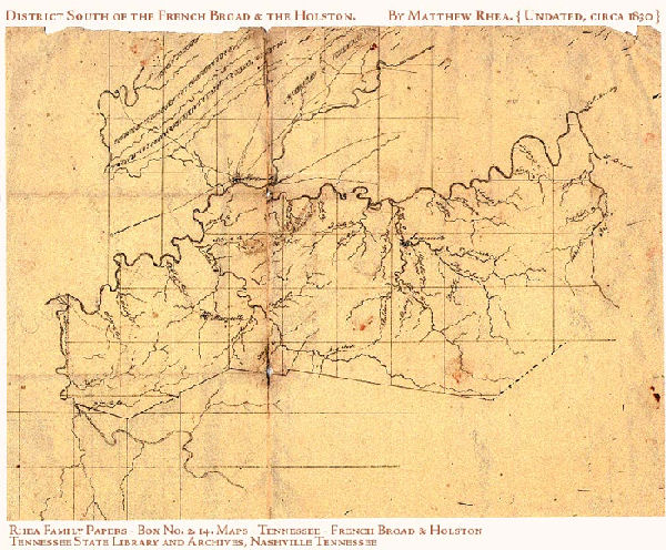
This district was formed on the bounds of the tract mentioned in the 1796 Tennessee State Constitution, Declaration of Rights, Section 31: “That the people residing south of the French Broad and Holston, bet the rivers Tennessee and the Big Pigeon, are entitled to the right of pre-emption and occupancy in that tract.” Even mentioned in the U. S. Congressional Act of 1806: “. . . the people residing in said State, south of French Broad and Holston, and west of the Big Pigeon Rivers provided for by the Constitution of the State of Tennessee, shall be secured in their respective rights of occupancy and pre-emption. . .” Most of the boundary rivers, above, have gone through name changes since 1790's. The river above Kingston but before Knoxville that was originally called the Holston, later became the Tennessee. The Big Pigeon became the Pigeon, and the then Tennessee is now the Little Tennessee. The southern line of this tract would cross over and into Cherokee lands. The dividing boundary was established in the 2 July 1791, Blount’s Treaty, also called the Treaty of Holston. The southern area of Blount County reached past the treaty line. It was not unusual for the county lines or even the later Surveyors’ District lines to cross treaty lines, only later to be open to legal settlement. In 1797, the Hawkins’ Line was surveyed. That line ran east-southeast from Kingston to Blanket Mountain, later being extended to “Megis’ Post” near Clingman Dome on Iron Mountain. 47 In the Treaty of Tellico, 2 Oct 1798, the Cherokees ceded more land in the southwest of Blount County, south of the original Hawkin0146s Line. Here the boundaries were extended southerly and also eastward to the Chilhowie Mountain area. At the conclusion of the treaty of Tellico a tract of land in southeast Blount County still remained in Cherokee hands.When it was formed in
1806, the boundary description of the French Broad and Holston
District was unspecific, according to Whitney. Here we need to
return to the Section 31 of the State Declaration of Rights.
The district’s southern boundary would simply be “Tennessee”
or Little Tennessee. However, it seems that the District did
not completely adhere to the Little Tennessee as its southern
boundary. Off limits to white settlement was a tract of Cherokee
land in southeast Blount County. This tract actually was to fall
into the 1819 Hiwassee District. Calhoun’s Treaty of 1819
extinguished all Cherokee claims north of the Hiwassee River
which, of course, included any Indian lands that remained north
of the Little Tennessee, in Blount County. With the use of the
1851 Hiwassee District map, TSLA #408, we can determine the boundary
bet this District south of the French Broad and Holston and the
Hiwassee the District.
|
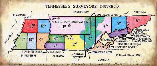
District South of the French Broad & Holston |
The 1806 East Tennessee Districts . . . District south of the French Broad & Holston [now called Little Tennessee River] . . . Located in East Tennessee . . . District Office was located at Sevierville.The 1819 East Tennessee District . . . the Hiwassee District located in southern East Tennessee . . . lands lately acquired by treaty from the Cherokee tribe of Indians, lying bet the Hiwassee, Big Tennessee and Little Tennessee Rivers, and north of Little Tennessee...” North of the Little Tennessee? This was the land in southeast Blount County that can found on various treaty boundary line maps . . . In 1833, it became lawful’to make entries...for any vacant and un-appropriated land lying in Blount County, within the Hiwassee District... ” |
p. 96, line 2: Samuel Patterson, 1 male 15-20, 1 male 60-70, 1 female 10-15, 1 15-20, 1 f. 50-60, 1 f. 80-90, 6 slaves.p. 2: Another Samuel Patterson.p. 5: Caleb Patterson (mistranscribed in printed census as Cobb Patterson), 1 male under 5, 1 male 20-30, 3 females under 5, 1 female 20-30; two pages earlier lived Samuel & David Patterson; two pages further lived possible father Charles 40-50 and brothers Cornelius and George, both 20-30.p. 7, lines 19-21: Charles Patterson, 1 male 5-10, 1 male 10-15. 1 male 15-20, 1 male 40-50, 2 females under 5, 1 female 5-10, 1 female 10-15, 2 females 15-20, 1 female 30-40; lived bet Cornelius Patterson as 1 male 20-30, 3 females under 5, 1 female 20-30, 1 female 60-70; and George Patterson as 1 male 20-30, 1 female 20-30.William T. Patterson and his sister Priscilla Patterson (in husband Joseph Longley's household) were in McMinn Co., TN by the 1830 census, and in Bradley Co., TN, for 1840 census. |
Book 1, p. 131
|


|
|
   |
|